Water Supply, Sewerage and Drainage Project
Water Supply, Sewerage and Drainage Project
Water Supply, Sewerage and Drainage Project
Our website is currently undergoing revisions to improve your experience.
Please check back soon for updates.
For inquiries, you may reach us at ctipilipinasinc@cti-p.com
Our website is currently undergoing revisions to improve your experience.
Please check back soon for updates.
For inquiries, you may reach us at ctipilipinasinc@cti-p.com
Our website is currently undergoing revisions to improve your experience.
Please check back soon for updates.
For inquiries, you may reach us at ctipilipinasinc@cti-p.com
Our Experience
Our Experience


PDS
CTIP-01
Project Name:Peer Review Consultancy Services for a Large-scale Tourism Estate Project in the Philippines
Narrative Description of the Project:
Palawan, is celebrated for its stunning coastal landscapes, limestone cliffs, and rich biodiversity, making it one of the Philippines’ premier tourism destinations. The area’s terrain is a mix of rugged hills and mountainous formations, with low‑lying coastal plains and stream valleys that provide both scenic appeal and environmental challenges. Its proximity and natural drainage features such as rivers, creeks, and swamp areas make hydrologic conditions a critical factor in any development effort.Within this setting lies a master‑planned tourism estate designed to integrate residential, commercial, institutional, and recreational components. The estate is strategically positioned near the river and adjacent to the bay, offering opportunities for sustainable tourism growth while also facing risks of flooding and storm surge. Existing developments, including the beach promenade and completed southern estate components, highlight the area’s potential, while new phases must carefully balance expansion with environmental resilience and long‑term flood management.
Start Date: April 2026
Completion Date: May 2026
The objectives of the study are: (1)Assess the technical soundness and completeness of the drainage system design drawings.(2)Validate design assumptions, parameters, and computations against current standards and site conditions.(3)Optimize the system layout, including pipe sizing and material selection for hydraulic and cost efficiency.(4)Ensure the design is cost-effective and aligned with environmental and safety standards.


HYDROLOGICAL REVIEW REPORT

Catchment Areas & Flows

Original Off-site Drainage Layout

Topography Map – DEM from STRM

Improved Off-site Drainage Layout
PDS
CTIP– 02
Project Name:Design & Build Service for the Project for the Expansion of Phum Prek Water Supply System
Narrative Description of the Project:
The Phum Prek Water Supply System in Cambodia is a vital infrastructure project designed to provide clean, reliable, and sustainable water to Phnom Penh and surrounding communities. Located along the Tonle Sap River, the facility plays a central role in addressing the growing demand for potable water in the capital, ensuring both urban households and industries have access to safe supply. By combining modern treatment technologies with expanded distribution networks, the project strengthens public health, supports economic development, and enhances resilience against climate-related challenges. Ultimately, the Phum Prek system represents a cornerstone of Cambodia’s long-term vision for equitable and sustainable urban growth.The water demand in the area supplied by PPWSA is projected to double in 2030 and construction of new WTP in Ta Khmau, which is located south suburban area of Phnom Penh, is vital for PPWSA to secure sufficient water supply in greater Phnom Pehn area. In this connection, grant aid was requested from the Royal Government of Cambodia. Responding the request, JICA formulated a project entitled “The Expansion of Water Supply System in Ta Khmau”. This project was started from Feasibility Study to bided as Design & Build (D&B) contract by PPWSA. The scope of the D&B contract is as shown in the table below

Start Date: May 2025
Completion Date: December 2025
Although raw water is taken from Bassac River flowing besides the WTP site, it was detected that the NH4+-N concentration in this raw water reached 3.35mg/L. The ammonia concentration was similar to that of WRF treated effluent. Therefore, in this project, the treatment of high-concentration ammonia was considered. Another unique feature of the WTP is vertical layered tank layout to fit with the extremely tight space conditions of the site. This project will improve access to safe water in Ta Khmau City through the expansion of the water supply system.
Description of Actual Services Provided in the Assignment:
CTI Pilipinas, Inc. (CTIP) provided the following services:
Design & Build (D&B) project for the expansion of Phum Prek Water Treatment Plant (WTP) in Phnom Penh, Cambodia
(a)Assist with Architectural design for the WTP
(b)Assist with Structural design for the WTP
(c)Assist with Mechanical design for the WTP
(d)Assist with Electrical design for the WTP
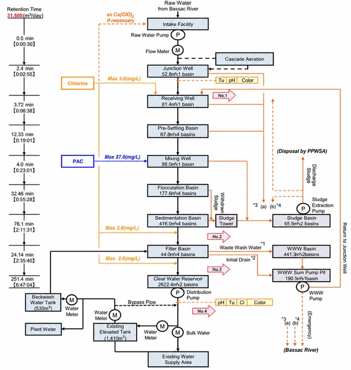
Flow Diagram of Water Treatment Process

WTP General Cross-Section

Construction Scene of WTP
PDS CTIP– 03
Project Name:Consulting Services for Master Plan and Feasibility Study on Flood Control and Drainage Improvement in the City of Ormoc
Narrative Description of the Project:
Ormoc City, located in northwestern Leyte with a land area of 46,430 ha, experiences frequent and disruptive flooding despite only 5% of its land being built‑up. Major events such as Typhoon Uring (Thelma) severely damaged roads, drainage, bridges, and affected schools and government operations. Flooding is concentrated in low‑lying barangays and is driven by restricted river flow, siltation, river overflow, dike breaches, back‑flooding, and inadequate drainage. Existing city initiatives, including the Ormoc Urban Waterscape Project, have identified broad strategies but lack a long‑term, basin‑wide mitigation framework.
To address this gap, the study aims to assess current drainage and river conditions, determine the causes of inundation, and establish a comprehensive flood control and drainage master plan based on a 25‑year return period. It also seeks to identify and prepare a feasibility study for priority projects. The study area covers west Ormoc City, excluding the separately studied Pagsanga‑an River Basin. Flood control efforts focus on the Jaobon River Basin (26.7 km²), while drainage improvements cover a 13.3 km² zone including major roads and 18 barangays.
The study was carried out by a multidisciplinary team of national and international experts, including data collection,
environmental and socio‑economic studies, hydrologic/hydraulic analysis, and master plan formulation.
As a result of these investigations, the following measures were proposed as MP:
Drainage Improvement
Start Date: October 2023
Completion Date: January 2025
Flood Control
-Construction of new drainage lines (19.65 km) and rehabilitation of existing lines (20.4 km)
-Installation of a retention pond / retarding basin (188,000 m³)
-Deployment of flap gates and pump gates at outfalls-Reconfiguration of outfalls in the port reclamation area
-Enhanced operation & maintenance (O&M)
-Non-structural measures: public awareness, solid-waste education, drainage asset database
-River channel improvement (Main, Co‑ob, Jaobon Rivers): widening (16–100m), dredging, slope protection, revetments, flood walls, dikes
-River realignment (1.9 km) in Jaobon River
-Three major retarding basins: RB1 (2,123,000 m³), RB2 (188,000 m³) and RB3 (1,090,000 m³)-Priority Project: Jaobon River (1.9km) and Retarding Basin 2 (188,000 m³)
-Non-structural measures: flood risk mapping, rain gauge monitoring, early warning system, land-useregulation, “No Build Zones,” emergency preparedness.
Description of Actual Services Provided in the Assignment:
CTI Pilipinas, Inc. (CTIP) provided the following services:
Primarily responsible for flood control measures
Conduct Surveys (Topographic, Geotechnical, Environmental, Socio-economic)
Hydraulic and Hydrologic Analysis
Flood Survey and Damage Analysis
Formulation of Master Plan and Implementation Plan
Environmental and Social Impact Study
Project Evaluation
Conduct Feasibility Study for the Priority Project

Flood Run-off Model

Simulation vs Flood Survey Result
PDS
CTIP – 04
Project Name:Flood Inundation Analysis for 18 Facilities in CAMANA Area
The Flood Control Team is conducting a comprehensive flood inundation analysis for 18 facilities in the CAMANA area, as part of Maynilad’s initiative to enhance wastewater management and sanitation in Metro Manila. This analysis involves a detailed field assessment of land conditions and surrounding hazards, including sediment impact and tidal influences. Key data acquisition includes topographic information, rainfall and tidal data, and land use patterns, which will inform hydrologic analysis and runoff modeling. The team will also perform site visits to verify conditions at each facility and collect necessary data for effective modeling.Following the data collection, the team will conduct hydrologic analyses to estimate probable rainfall and discharge for various return periods, ultimately developing two-dimensional (2D) flood inundation model. The results will include flood inundation depths for each facility at different return intervals, providing critical insights for flood risk management
Narrative Description of the Project:
Start Date: November 2022
Completion Date: February 2023
The Flood Control Team is conducting a comprehensive flood inundation analysis for 18 facilities in the CAMANA area, as part of Maynilad’s initiative to enhance wastewater management and sanitation in Metro Manila. This analysis involves a detailed field assessment of land conditions and surrounding hazards, including sediment impact and tidal influences. Key data acquisition includes topographic information, rainfall and tidal data, and land use patterns, which will inform hydrologic analysis and runoff modeling. The team will also perform site visits to verify conditions at each facility and collect necessary data for effective modeling.Following the data collection, the team will conduct hydrologic analyses to estimate probable rainfall and discharge for various return periods, ultimately developing two-dimensional (2D) flood inundation model. The results will include flood inundation depths for each facility at different return intervals, providing critical insights for flood risk management.
Description of Actual Services Provided in the Assignment:
CTI Pilipinas, Inc. (CTIP) provided the following services:
-
Field Assessment
–Conducted evaluations of land conditions at target facilities, including topography and surrounding hazards.
–Assessed river and drainage channel conditions, focusing on catchment area characteristics.
–Performed field reconnaissance by visiting 18 lifting and pumping stations.
-
Basic Data Acquisition
–Topographic, rainfall data, land use data etc.
-
Formulation of Master Plan and Implementation Plan
-
Hydrologic AnalysisFlood Inundation Analysis
-
Reporting

Pump/Lift Stations


Inundation Study Result
PDS
CTIP–05
Project Name:Risk Analysis Against Flood and Storm Surge for XXX Industry in the Philippines (*XXX is private company name)
Narrative Description of the Project:
The Flood Control Team is conducting a comprehensive flood inundation analysis for 18 facilities in the CAMANA area, as part of Maynilad’s initiative to enhance wastewater management and sanitation in Metro Manila. This analysis involves a detailed field assessment of land conditions and surrounding hazards, including sediment impact and tidal influences. Key data acquisition includes topographic information, rainfall and tidal data, and land use patterns, which will inform hydrologic analysis and runoff modeling. The team will also perform site visits to verify conditions at each facility and collect necessary data for effective modeling.Following the data collection, the team will conduct hydrologic analyses to estimate probable rainfall and discharge for various return periods, ultimately developing two-dimensional (2D) flood inundation model. The results will include flood inundation depths for each facility at different return intervals, providing critical insights for flood risk management
Start Date: October 2022
Completion Date: December 2023
Description of Actual Services Provided in the Assignment:
CTI Pilipinas, Inc. (CTIP) provided the following services:
-
Data Collection such as typhoon information (track, wind, air pressure), tide level, rainfall, DEM, oceanographic data, ground elevation of the industry, etc. and statistical analysis of rainfall and tidal level
-
Flood Risk Analysis with rainfall analysis, runoff analysis and flood inundation model
-
Tide Deviation Analysis with analysis of target typhoon and storm surge simulation model
-
Wave height analysis with SWAN model
-
Climate change Consideration
-
Reporting

Result of Flood Inundation Analysis

Result of Wave Height Analysis

Typhoon Tracks
PDS
CTIP- 06
Project Name:Consulting Services for Master Plan on Drainage Improvement in Municipality of Dinalupihan
Narrative Description of Project:
Dinalupihan is an agricultural town in the province of Bataan, situated along 95 kms eastern side of Manila which is accessible via North Luzon Expressway. It is the lone landlocked town in Bataan; bounded on the north by Floridablanca, Pampanga; on the east by Lubao, Pampanga; on the south by Hermosa, Bataan and on the west by Olongapo City.Guided by its vision to turn the town into a model agropolis by 2022, the Municipality of Dinalupihan has been undergoing a rapid economic development in the areas of agriculture, agro-industrial, agri-tourism, and urban service centers while protecting its biodiversity and caring for the environment.However, the town’s vision is perenniallybeing threatened by flood disasters, which times in the last 10 years; affecting barangays, residents, and their livelihood. If not mitigated, flood damage will increase due to the effects of urban development in the future.
The floods and inundation occur mainly from the following reasons: 1) restricted flow of rivers due to blocked natural channels; 2) excessive surface runoff coming from areas of higher elevation; 3) siltation and riverbank erosion along unprotected portions of the creek/river; 4) overflow from creeks/rivers; 5) breaching of the dike protecting the rivers; 5) water impoundment structures; 6) back flooding; 7) construction of the tunnels crossing SCTEx; and 8) inadequate drainage systems. However, because of the technical and financial constraint of the local government, long-term flood mitigation measures as well as basin-wide flood control plans are not yet established in any implementation program.
Under these circumstances, a comprehensive urban drainage master plan was deemed indispensable to provide a safer and
more pleasant life for the residents and facilitate the town’s sustainable economic development.
Start Date: December 2021
Completion Date: March 2022
Project Area Map

Main Objectives
(1)To study the existing conditions of the drainages, creeks, and canals, and its interconnections
(2)To determine the main cause of inundation in the concerned areas
(3)To establish and effective drainage master plan, applying a 25-year return period
Description of Actual Services Provided in the Assignment:
CTI Pilipinas, Inc. (CTIP) provided the following services:
•Field Reconnaissance and Basic Data Collection
•Flood Damage Survey
•River, Canal, Drainage, And Topographic Survey
•Analysis of the Result of the Basic Survey and Studies
•Hydraulic and Hydrologic Analysis
•Formulation and Preparation of Drainage Master Plan
•Selection of Priority Project
•Reporting and Meeting

Result of Inundation Analysis


Sample of Proposed Countermeasures
PDS
CTIP – 07
Project Name:Jeneberang River Flood Inundation ModelingConsultant’s Key Experts:Maria Cristelle A. San Antonio (Hydrologist) Marciel Ronquillo (Modelling)
Narrative Description of the Project:
The Jeneberang River, a major waterway in South Sulawesi, Indonesia, spans approximately 75 km and encompasses a catchment area of 860 km², with significant reservoirs at Bili-Bili and Jenelata. During storm events, the river channels substantial water flow into the Makassar Strait. In January 2019, continuous rainfall caused the Bili-Bili Dam to exceed its normal water level, resulting in the river overflowing and flooding that affected 106 villages across 13 districts, as reported by the National Agency for Disaster Management.In response to this disaster, CTI Pilipinas, Inc. (CTIP) develop a comprehensive flood inundation model to mitigate future flooding risks. Utilizing the Hydrologic Engineering Center’s River Analysis System (HEC-RAS), we created a one-dimensional model for steady flows to simulate potential peak flows and a coupled 1D/2D model. This coupled approach allows us to analyze flood behavior within the river (1D channel) under unsteady flow conditions and assess the extent of inundation across the floodplain (2D flow area) when the river overtops. This modeling initiative aims to enhance disaster preparedness and inform effective flood mitigation strategies for vulnerable communities.
Description of Actual Services Provided in the Assignment:
The main scopes of the Consulting Services are:
•Model Development using HEC-RAS
•Simulation and Validation
•Inundation Mapping

Results of 2D Unsteady Flow Modeling for the Jeneberang River
PDS
CTIP – 08
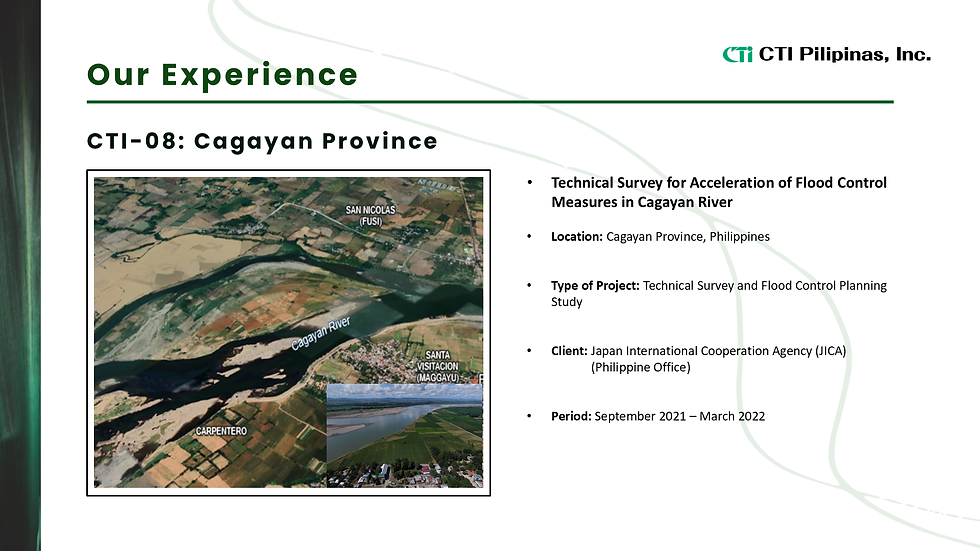
Project Name:Technical Survey for Acceleration of Flood Control Measures in Cagayan River
Narrative Description of the Project:
This study aims to:
(1)Evaluate the scale of flood and damage caused by Typhoon Ulysses
(2)Revie and recommend the necessity of updating 2002 M/P
(3)Formulate “Roadmap” which is consolidates the procedure of flood control measures for several years in order to expedite DPWH’s effort
Contents of this study are:
–Preparation of Inception Report
–Collection and Sort Out Basic Data–Hydrological/Hydraulic Analysis and Runoff Analysis
–Presentation of Progress Report–Evaluation of Flood Control Measures and Formulation of Roadmap
Start Date: September 2021
Completion Date: March 2022
Description of Actual Services Provided in the Assignment:
The main scopes of the Consulting Services are:
•Preparation of Inception Report
•Data and Information Collection on Flood Damage such as rainfall data, geographical data and river structure
•Evaluation of the scale of the Typhoon Ulysses by rainfall, discharge and water level
•Evaluation of the progress of flood control measures in the river